$1 / person
4days
Meduim
Kyrgyzstan

Highlights and Overview of this Trip
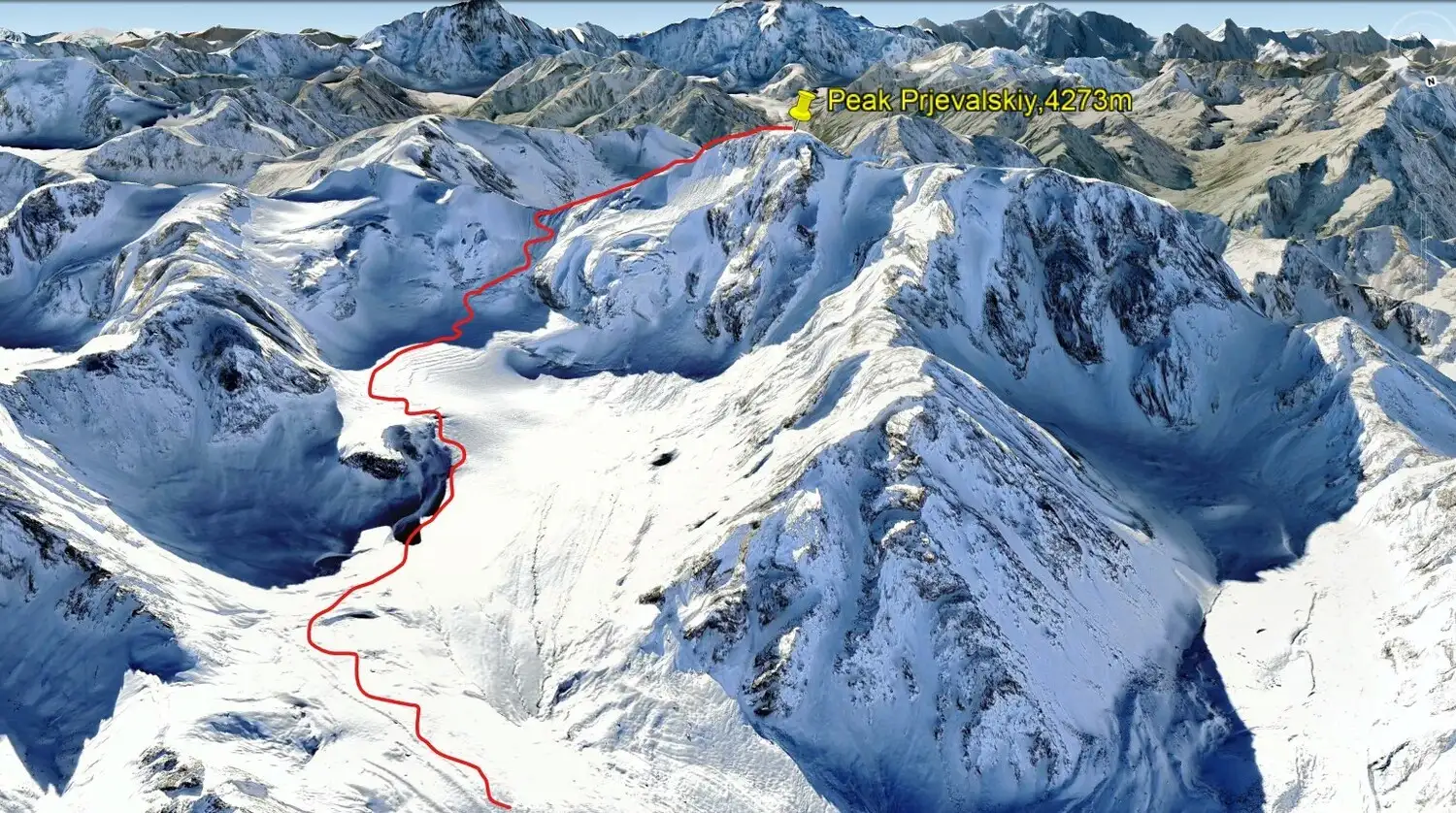
Welcome to the ascent of one of the most impressive peaks – Peak Przhevalsky! From this height of 4,273 meters, you can enjoy incredible views and experience the grandeur of the mountain landscapes.
Named after the renowned Russian explorer Nikolay Przhevalsky, Peak Przhevalsky towers above the picturesque town of Karakol. Its sharp rocky cliffs, surrounded by snow and ice, create a unique atmosphere that evokes awe in every traveler.
Avoiding difficult mountaineering routes, we offer the easiest and safest route to reach the summit. An experienced guide will accompany you throughout the journey, ensuring safety and comfort. You don’t need specialized mountaineering skills to conquer this peak – being in good physical shape and having a thirst for adventure is enough.
With each step upwards, you will feel increasing energy and excitement, and when you reach the summit, you will be rewarded with unparalleled views of the surrounding area. Open your gaze to breathtaking panoramas of Lake Issyk-Kul, Lake Alakul, and the highest peaks of this region. On a clear day, you may even catch a glimpse of the distant Khan Tengri Peak, located 200 kilometers away.
DESCRIPTION FOR TREKKING PROGRAM:
The peak that is visible from any point in the city of Karakol 4273m. Sharp-pointed rocks framed by snow and ice. There are several ways to conquer the summit. We will take the easiest and safest route that does not require any mountaineering knowledge from participants. An experienced guide will handle all technical aspects. From the top, you will enjoy an unforgettable view of the surroundings, Lake Issyk-Kul, Lake Alakul, and the highest peaks of this region. On a clear day, you can even see Khan Tengri Peak, which is located 200 km away from Przhevalskiy Peak.
The journey to Peak Prejevalsky is not only a physical challenge but also an opportunity to immerse you in the world of nature and the grandeur of mountains. The captivating beauty of these places will leave you with unforgettable impressions and a sense of connection with nature.
Total Km of Trekking: 35km
Elevation Min/Max: 1700m/4273m
Start Point: Karakol National Park
End Point: Karakol Ski Base
Trip season: July -October
Duration: 4 Days
Type: Trekking / Climbing
Difficulty: Medium, Hard
Accommodation: Tents
Meals: Full board – breakfasts, Lunches, Dinners.
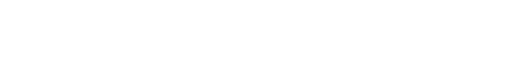
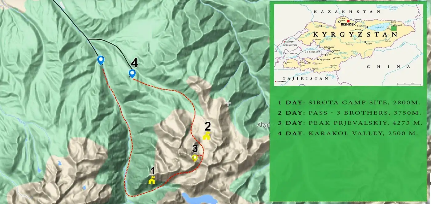
Route: Karakol Town – Sirota Yurt Camp – Pass 3 Brothers – Peak Prjevalskiy – Karakol Ski Base – Karakol Town
HIGHLIGHTS:
- Tien Shan Mountains
- Peak Prjevalskiy 4273 m
- High passes, panoramic views
PROGRAM:
DAY 1: Karakol – National Park – Sirota Camp Site
Transfer to the beginning of the hiking route. Proceed through the Karakol Gorge until reaching the confluence with the Kurgaktor Gorge. Enjoy a delicious lunch along the way. Set up camp at an elevation of 2800 meters at the “Orphan” campsite. Indulge in a satisfying dinner. Overnight in a tent.
Meals included:
Lunch box, Dinner
Minimum altitude: 2040 meters
Average altitude: 2330 meters
Maximum altitude: 2900 meters
On foot: 14 kilometers
Maximum gradient: 35%
Average gradient: 10%
Travel time: 6-7 hours
Route difficulty: 2A
DAY 2: Sirota Camp – Pass 3 Brothers
Enjoy a hearty breakfast to fuel up for the challenging ascent through the Kurgaktor Gorge towards the “Three Brothers” pass. Have a well-deserved lunch along the way. Spend the night at the Termitor Pass, where you’ll set up camp. Indulge in a delicious dinner before retiring to your tents for the night at an elevation of 3750 meters.
Meals included:
Breakfast, Lunch box, Dinner
Minimum altitude: 2900 meters
Average altitude: 3372 meters
Maximum altitude: 3907 meters
Distance on foot: 6 km
Maximum gradient: 45%
Average gradient: 28%
Travel time: 6-7 hours
DAY 3: Pass Termitor – Peak Prjevalskiy
Breakfast. Start ascending to the Peak Of Prjevalskiy. Today, we will navigate with precision, roped together, and gracefully tread upon the icy terrain with the aid of crampons. Along our journey, we will indulge in a delightful midday lunch. As the day unfolds, we will descend into the enchanting Termitor Gorge, where nature’s wonders await. As the sun sets, we will relish a delectable dinner, savoring the flavors of the wilderness.
Meals included:
Breakfast, Lunch box, Dinner
Minimum altitude: 3750 meters
Average altitude: 3980 meters
Maximum altitude: 4273 meters
Distance on foot: 4 km
Maximum gradient: 52%
Average gradient: 39%
Travel time: 6-7 hours
DAY 4: Termitor Valley – Karakol Town
Breakfast. Descent into Termitor Gorge. Descent into Karakol Gorge until the first bridge. Transfer to the city of Karakol.
Meals included:
Breakfast, Lunch box, Dinner
Minimum altitude: 2400 meters
Average altitude: 3125 meters
Maximum altitude: 3780 meters
Distance on foot: 11 kilometers
Maximum gradient: 45%
Average gradient: 22%
Travel time: 6-7 hours
Notes:
Equipment and items for the trekking / climbing:
- Sleeping bag suitable for temperatures as low as -10°C.
- Sturdy trekking boots with proper ankle support and a reliable tread. It’s also advisable to carry an extra pair of shoes or sandals in case your main footwear gets wet during rain or other unforeseen circumstances.
- Waterproof rain jacket and trousers to protect you from rain and wet conditions.
- Crampons and Ice Axe.
- Warm clothing and extra layers for changing weather conditions.
- Hat and cap to shield yourself from the sun, along with sunglasses and high-factor sun cream to protect your skin.
- A daypack with a capacity of max. 30 liters and a rain cover to keep your belongings dry. It’s also a good idea to line your daypack with a quality plastic bag for added protection. Think about how much you want to carry during trekking and choose a good backpack.
- Head-torch for navigating in low-light conditions or during nighttime.
- Water bottle to stay hydrated throughout the trek. We’ll collect water from rivers or springs during trekking. It’s necessary to bring your own water bottle and, if needed, water purifiers or filters to ensure an eco-friendly and independent trekking experience.
- Quick-drying towel for personal hygiene and drying off.
- A first aid kit, especially if you have any pre-existing medical conditions or require specific medication.
These essential items will ensure your comfort, safety, and preparedness during the trekking adventure.
Physical requirements:
Participants must be in good physical condition, but don’t need any special mountaineering skills. The differences of heights range from 600 m to 850 m in vertical elevation. The maximum elevation is 4273 m.
Personnel
At Red Mount, we prioritize safety and ensure that our customers are accompanied by experienced mountain guides. Our guides are highly knowledgeable in trekking and mountaineering safety, guaranteeing a secure and enjoyable journey.
Prices and Booking
Please contact us for more information and pricing.
The price varies depending on your group size, experience and preferences.
We are here to help, feel free to ask for any further assistance or clarification.